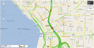
When you're on your way somewhere, you probably want to know how long it's going to take to get there, and now Google Maps incorporates real-time traffic conditions in its directions to help factor that in.
As posted on the Google Lat Long Blog, typing in a starting point and a destination will give users an estimated time with current traffic conditions -- a valuable tool for those on the go who don't want to waste valuable gas idling in traffic.
You could already view a layer of live traffic on routes, but this added bit of information now gets crunched when calculating routes.
Google
Comparing driving time vs. transit time on Google Maps
If that sounds familiar, it's because Google Maps used to show estimates of trip times based on traffic. But users found it wasn't always the most accurate gauge of real conditions, so the feature went away last year. Now it's back, and it's supposed to be better because it's constantly being refreshed.
Where does the fresh data come from? Android users. Those who have their location services enabled (i.e., those who have no problem with being tracked, albeit anonymously) and have opted to use the My Location feature on Google Maps for mobile contribute to the traffic info:
Google
Screenshot of traffic layer on Google Maps
When we combine your speed with the speed of other phones on the road, across thousands of phones moving around a city at any given time, we can get a pretty good picture of live traffic conditions. We continuously combine this data and send it back to you for free in the Google Maps traffic layers. It takes almost zero effort on your part — just turn on Google Maps for mobile before starting your car — and the more people that participate, the better the resulting traffic reports get for everybody.
This new feature comes with other changes to Google Maps, notably Street View, which has exploded all over the world, with new images for international voyeurs to feast their eyes on in Thailand, the Amazon, Poland and Japan, where the cherry blossoms are in full bloom.


No comments:
Post a Comment